

Aztec Math Decoded, Reveals Woes of Ancient Tax Time
Sunday, April 06 2008 @ 10:50 AM CDT Views: 1,011

Brian Handwerk
Today's tax codes are complicated, but the ancient Aztecs likely shared your pain.
To measure tracts of taxable land, Aztec mathematicians had to develop their own specialized arithmetic, which has only now been decoded.
By reading Aztec records from the city-state of Tepetlaoztoc, a pair of scientists recently figured out the complicated equations and fractions that officials once used to determine the size of land on which tributes were paid.
Two ancient codices, written from A.D. 1540 to 1544, survive from Tepetlaoztoc. They record each household and its number of members, the amount of land owned, and soil types such as stony, sandy, or "yellow earth."
"The ancient texts were extremely detailed and well organized, because landowners often had to pay tribute according to the value of their holdings," said co-author Maria del Carmen Jorge y Jorge at the National Autonomous University in Mexico City, Mexico.
The Aztecs recorded only the total area of each parcel and the length of the four sides of its perimeter, Jorge y Jorge explained.
Officials calculated the size of each parcel using a series of five algorithms—including one also employed by the ancient Sumerians—she added.
"Rule of Thumb" and Other Body Parts
The Aztec arithmetic included fractional symbols like hearts, hands, and arrows that seem unusual to modern eyes. But to the Aztecs they likely had a relation to the familiar—the human body.
"For example the heart," Jorge y Jorge said.
"If you stretch out your left arm, that would be the measure from your heart to the tip of your finger. If you stretch both arms, the measure of the hand would be the distance between the tips of your two fingers.
"It's just very natural. Your body you carry with you all the time and it's very easy to refer whatever you want to measure to your body."
The primary land unit was likely the distance from the ground to the tip of a finger on an adult's upraised right arm—about 8.2 feet (2.5 meters), she said.
Jorge y Jorge and co-author B.J. Williams of the University of Wisconsin-Rock County report their findings in this week's issue of the journal Science.
"I think [the study] is neat because it shows that this sort of math and science was pretty practical in orientation," said Michael Smith, an archaeologist and Aztec expert at Arizona State University.
(Read related story: "Inca Tax Records Were Tied Up in Knots, Study Says" [August 11, 2005].)
"We have the idea that ancient societies were dominated by religion. Yeah, religion was important, but they were also very practical people doing very practical things," Smith said.
"With this sort of rule-of-thumb surveyor's math, they figured out a way to get it done."
nationalgeographic.com
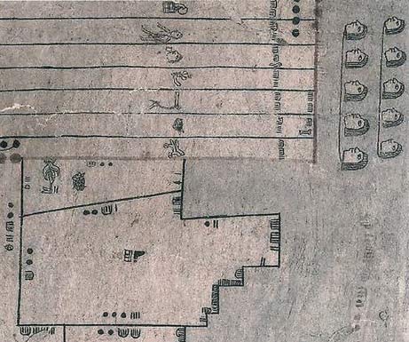
A map drawn in 1540 depicts parcels of land near Texcoco, an ancient Aztec capital.
A new study has deciphered the glyphs used to calculate the measurements of such parcels, including symbols like hearts, hands, and arrows, which denoted fractions.
Image courtesy of Library of Congress, Geography and Map Division
More below the book ads

http://hiddenmysteries.com/xcart/product.php?productid=17384
http://hiddenmysteries.com/xcart/product.php?productid=17376
Aztec Math Used Hearts and Arrows
How big is a heart? Two and a half land rods of course, according to the Aztecs
By David Biello
The Aztecs had more numbers than we do, or at least symbols denoting numerical concepts. When it came to measuring land—critical for levying the proper tax or tribute—these medieval Mesoamericans used arrows, hearts, hands and other units representing fractions, according to a new study in Science.
To figure this out, mathematician Maria del Carmen Jorge y Jorge of the National Autonomous University of Mexico (U.N.A.M) channeled the mind of an Aztec land surveyor. That meant retraining herself to use a different numerical system and combing through the Codex Vergara, one of two remaining books that record Aztec land surveying.
Working with geographer Barbara Williams and del Carmen Jorge y Jorge counted 367 fields in this book with both an overall area for the plot of land as well as the lengths of the sides. Roughly 60 percent of these fields had areas that matched the basic mathematical rule of length multiplied by width or other common surveying calculations.
But the rest were off, usually by a small amount. And 69 had areas that were prime numbers such as 211—numbers that cannot be created by multiplying two whole numbers together, such as 20 times 10. Instead, del Carmen Jorge y Jorge determined that the Aztecs were using the equivalent of fractions.
"We found these smaller units of measure that we call monads that have the role of a fraction," she says. "We don't like to call them fractions, though, because they were considered as unitary entities like inches, seconds or minutes."
To denote half the Aztec basic unit of measure—known by Aztec experts as tlalquahuitl or land rods—the surveyors used an arrow symbol. So for a field that measured 20 land rods by 10 land rods plus an arrow (or 20 multiplied by 10.5), the correct area was 210. "Two arrows is one unit, five hearts is two units, five hands is three units," del Carmen Jorge y Jorge notes.
These extra units—arrow, heart, hand, bone and arm—cannot be subdivided further, standing alone as essentially extra numbers. It is unclear what exactly these measurements equal, but the team speculates that an arrow is the measure of the length from the shoulder to the hand (like an archer with a taut bow), a heart is a measure of the length from that organ to the tip of the hand and a hand as the measure from outstretched hand to outstretched hand—just as an English foot is the measure of a man's foot. "That could be an interpretation," del Carmen Jorge y Jorge says. "We cannot prove it."
The researchers will next try to assess the accuracy of the Aztec surveyors. The neighborhood of Asuncion outside Mexico City still bears the markings of the ancient Aztec terraced fields on its hillsides that were recorded in the Codex Vergara. "We were there trying to measure those terraces," del Carmen Jorge y Jorge says. "This is complicated because this is sloping land."
It is no doubt easier to measure sloping land with modern devices like satellite global positioning systems and computers than it is to try to inhabit an alternative mathematical system and devise the meaning of mysterious symbols—as well as grasp the algorithms that can explain how they were used. "I can use my math, my computers and whatever I want," she says. "With this paper, I am only using hand calculations."
sciam.com


What's Related